|
|
|||||||||||||||||
| Point ID: 719 | Downloads | Plots | Site Data | Code: 07DB001 |
|
|
|||||||||||||||||
| Download | |
|---|---|
| Site Descriptor Information | Site Time Series Data |
| Link to all available data | |
| View: | Time Series | All |
| Units: | m3/s |
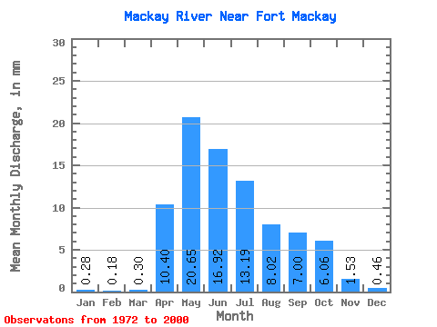
| Statistic | Jan | Feb | Mar | Apr | May | Jun | Jul | Aug | Sep | Oct | Nov | Dec | Annual |
|---|---|---|---|---|---|---|---|---|---|---|---|---|---|
| Mean | 0.28 | 0.18 | 0.30 | 10.40 | 20.65 | 16.92 | 13.19 | 8.02 | 7.00 | 6.06 | 1.53 | 0.46 | 75.50 |
| Standard Deviation | 0.13 | 0.09 | 0.23 | 11.20 | 16.48 | 16.73 | 13.37 | 8.02 | 9.30 | 6.70 | 1.04 | 0.28 | 40.50 |
| Min | 0.06 | 0.05 | 0.07 | 0.89 | 1.63 | 0.68 | 0.34 | 0.26 | 0.06 | 0.29 | 0.32 | 0.14 | 24.41 |
| Max | 0.56 | 0.40 | 1.05 | 45.84 | 61.54 | 73.06 | 53.85 | 36.68 | 36.39 | 26.97 | 3.50 | 0.95 | 153.20 |
| Coefficient of Variation | 0.48 | 0.51 | 0.75 | 1.08 | 0.80 | 0.99 | 1.01 | 1.00 | 1.33 | 1.11 | 0.68 | 0.62 | 0.54 |
 Return to R-Arctic Net Home Page