|
|
|||||||||||||||||
| Point ID: 7188 | Downloads | Plots | Site Data | Code: 12136 |
|
|
|||||||||||||||||
| Download | |
|---|---|
| Site Descriptor Information | Site Time Series Data |
| Link to all available data | |
| View: | Time Series | All |
| Units: | m3/s |
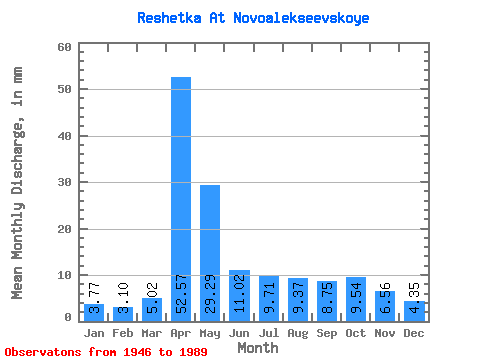
| Statistic | Jan | Feb | Mar | Apr | May | Jun | Jul | Aug | Sep | Oct | Nov | Dec | Annual |
|---|---|---|---|---|---|---|---|---|---|---|---|---|---|
| Mean | 3.76 | 3.11 | 5.03 | 52.59 | 29.26 | 11.06 | 9.70 | 9.34 | 8.71 | 9.51 | 6.56 | 4.32 | 153.07 |
| Standard Deviation | 1.63 | 1.46 | 3.70 | 20.07 | 25.33 | 7.03 | 7.81 | 9.80 | 7.46 | 8.51 | 4.33 | 2.04 | 54.59 |
| Min | 1.09 | 0.99 | 1.67 | 14.58 | 5.69 | 2.75 | 1.67 | 1.42 | 1.46 | 2.43 | 1.70 | 1.34 | 67.97 |
| Max | 8.20 | 7.62 | 18.41 | 116.64 | 159.84 | 28.35 | 35.15 | 49.38 | 39.69 | 50.21 | 25.92 | 10.04 | 303.68 |
| Coefficient of Variation | 0.43 | 0.47 | 0.74 | 0.38 | 0.87 | 0.64 | 0.81 | 1.05 | 0.86 | 0.90 | 0.66 | 0.47 | 0.36 |
 Return to R-Arctic Net Home Page