|
|
|||||||||||||||||
| Point ID: 7187 | Downloads | Plots | Site Data | Code: 12135 |
|
|
|||||||||||||||||
| Download | |
|---|---|
| Site Descriptor Information | Site Time Series Data |
| Link to all available data | |
| View: | Time Series | All |
| Units: | m3/s |
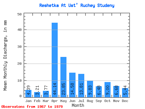
| Statistic | Jan | Feb | Mar | Apr | May | Jun | Jul | Aug | Sep | Oct | Nov | Dec | Annual |
|---|---|---|---|---|---|---|---|---|---|---|---|---|---|
| Mean | 4.34 | 3.16 | 3.79 | 44.20 | 23.78 | 14.56 | 13.88 | 9.89 | 6.53 | 9.08 | 6.78 | 5.35 | 150.83 |
| Standard Deviation | 2.60 | 1.76 | 1.50 | 32.28 | 13.62 | 13.65 | 9.29 | 7.74 | 4.38 | 6.14 | 3.96 | 3.32 | 62.29 |
| Min | 1.05 | 0.76 | 2.09 | 0.20 | 8.16 | 3.24 | 0.21 | 2.72 | 0.41 | 1.88 | 1.82 | 1.47 | 43.15 |
| Max | 9.41 | 6.10 | 6.07 | 100.84 | 46.24 | 53.66 | 29.50 | 29.29 | 13.77 | 19.25 | 13.37 | 12.97 | 246.36 |
| Coefficient of Variation | 0.60 | 0.56 | 0.40 | 0.73 | 0.57 | 0.94 | 0.67 | 0.78 | 0.67 | 0.68 | 0.58 | 0.62 | 0.41 |
 Return to R-Arctic Net Home Page