|
|
|||||||||||||||||
| Point ID: 7185 | Downloads | Plots | Site Data | Code: 12129 |
|
|
|||||||||||||||||
| Download | |
|---|---|
| Site Descriptor Information | Site Time Series Data |
| Link to all available data | |
| View: | Time Series | All |
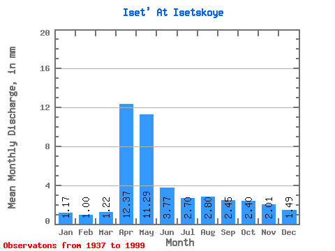
| Units: | m3/s |
| Statistic | Jan | Feb | Mar | Apr | May | Jun | Jul | Aug | Sep | Oct | Nov | Dec | Annual |
|---|---|---|---|---|---|---|---|---|---|---|---|---|---|
| Mean | 1.07 | 0.93 | 1.12 | 11.35 | 10.36 | 3.46 | 2.48 | 2.57 | 2.25 | 2.20 | 1.85 | 1.36 | 41.19 |
| Standard Deviation | 0.60 | 0.50 | 0.64 | 9.11 | 7.99 | 2.44 | 1.71 | 2.30 | 2.23 | 1.65 | 1.35 | 0.84 | 22.35 |
| Min | 0.19 | 0.20 | 0.20 | 0.69 | 1.62 | 0.88 | 0.64 | 0.67 | 0.68 | 0.66 | 0.52 | 0.35 | 12.85 |
| Max | 3.01 | 2.54 | 3.43 | 42.12 | 41.65 | 12.36 | 10.33 | 11.43 | 15.60 | 8.94 | 7.50 | 4.07 | 100.59 |
| Coefficient of Variation | 0.56 | 0.54 | 0.57 | 0.80 | 0.77 | 0.70 | 0.69 | 0.89 | 0.99 | 0.75 | 0.73 | 0.61 | 0.54 |
 Return to R-Arctic Net Home Page