|
|
|||||||||||||||||
| Point ID: 7179 | Downloads | Plots | Site Data | Code: 12113 |
|
|
|||||||||||||||||
| Download | |
|---|---|
| Site Descriptor Information | Site Time Series Data |
| Link to all available data | |
| View: | Time Series | All |
| Units: | m3/s |
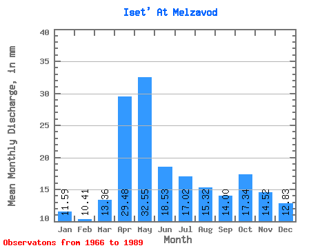
| Statistic | Jan | Feb | Mar | Apr | May | Jun | Jul | Aug | Sep | Oct | Nov | Dec | Annual |
|---|---|---|---|---|---|---|---|---|---|---|---|---|---|
| Mean | 11.59 | 10.50 | 13.36 | 29.48 | 32.54 | 18.53 | 17.02 | 15.32 | 14.00 | 17.34 | 14.52 | 12.82 | 207.91 |
| Standard Deviation | 3.51 | 3.22 | 5.39 | 14.15 | 19.64 | 7.17 | 8.59 | 7.47 | 7.49 | 11.33 | 7.82 | 3.70 | 69.57 |
| Min | 7.00 | 6.49 | 7.49 | 9.03 | 7.63 | 7.48 | 7.32 | 7.05 | 6.28 | 7.38 | 7.07 | 7.12 | 96.61 |
| Max | 21.50 | 18.42 | 25.87 | 61.01 | 76.33 | 33.85 | 38.80 | 40.44 | 37.91 | 49.55 | 41.61 | 23.68 | 357.02 |
| Coefficient of Variation | 0.30 | 0.31 | 0.40 | 0.48 | 0.60 | 0.39 | 0.51 | 0.49 | 0.54 | 0.65 | 0.54 | 0.29 | 0.34 |
 Return to R-Arctic Net Home Page