|
|
|||||||||||||||||
| Point ID: 7175 | Downloads | Plots | Site Data | Code: 12099 |
|
|
|||||||||||||||||
| Download | |
|---|---|
| Site Descriptor Information | Site Time Series Data |
| Link to all available data | |
| View: | Time Series | All |
| Units: | m3/s |
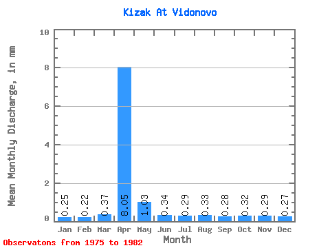
| Statistic | Jan | Feb | Mar | Apr | May | Jun | Jul | Aug | Sep | Oct | Nov | Dec | Annual |
|---|---|---|---|---|---|---|---|---|---|---|---|---|---|
| Mean | 0.25 | 0.23 | 0.37 | 8.05 | 1.03 | 0.34 | 0.29 | 0.33 | 0.28 | 0.32 | 0.29 | 0.27 | 12.68 |
| Standard Deviation | 0.04 | 0.06 | 0.24 | 6.18 | 0.67 | 0.17 | 0.13 | 0.02 | 0.03 | 0.03 | 0.05 | 0.05 | 7.51 |
| Min | 0.18 | 0.18 | 0.20 | 2.30 | 0.57 | 0.10 | 0.08 | 0.31 | 0.23 | 0.26 | 0.19 | 0.20 | 5.97 |
| Max | 0.30 | 0.30 | 0.80 | 20.99 | 2.45 | 0.58 | 0.43 | 0.36 | 0.32 | 0.35 | 0.34 | 0.32 | 26.70 |
| Coefficient of Variation | 0.16 | 0.24 | 0.65 | 0.77 | 0.65 | 0.51 | 0.46 | 0.06 | 0.12 | 0.10 | 0.17 | 0.17 | 0.59 |
 Return to R-Arctic Net Home Page