|
|
|||||||||||||||||
| Point ID: 7167 | Downloads | Plots | Site Data | Code: 12059 |
|
|
|||||||||||||||||
| Download | |
|---|---|
| Site Descriptor Information | Site Time Series Data |
| Link to all available data | |
| View: | Time Series | All |
| Units: | m3/s |
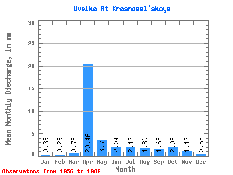
| Statistic | Jan | Feb | Mar | Apr | May | Jun | Jul | Aug | Sep | Oct | Nov | Dec | Annual |
|---|---|---|---|---|---|---|---|---|---|---|---|---|---|
| Mean | 0.39 | 0.29 | 0.75 | 20.46 | 3.71 | 2.04 | 2.12 | 1.80 | 1.68 | 2.05 | 1.18 | 0.56 | 37.48 |
| Standard Deviation | 0.26 | 0.18 | 1.02 | 12.72 | 2.88 | 0.95 | 1.69 | 1.31 | 0.93 | 1.02 | 0.57 | 0.26 | 18.34 |
| Min | 0.03 | 0.00 | 0.05 | 2.41 | 0.80 | 0.29 | 0.33 | 0.27 | 0.29 | 0.55 | 0.27 | 0.12 | 6.19 |
| Max | 1.09 | 0.62 | 5.36 | 50.91 | 14.35 | 4.53 | 8.51 | 6.05 | 4.58 | 4.55 | 2.51 | 1.16 | 72.03 |
| Coefficient of Variation | 0.66 | 0.64 | 1.37 | 0.62 | 0.78 | 0.46 | 0.80 | 0.73 | 0.55 | 0.50 | 0.48 | 0.46 | 0.49 |
 Return to R-Arctic Net Home Page