|
|
|||||||||||||||||
| Point ID: 7159 | Downloads | Plots | Site Data | Code: 12032 |
|
|
|||||||||||||||||
| Download | |
|---|---|
| Site Descriptor Information | Site Time Series Data |
| Link to all available data | |
| View: | Time Series | All |
| Units: | m3/s |
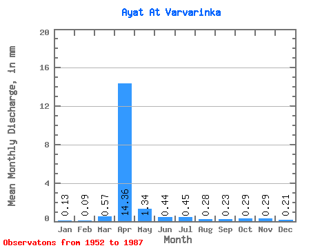
| Statistic | Jan | Feb | Mar | Apr | May | Jun | Jul | Aug | Sep | Oct | Nov | Dec | Annual |
|---|---|---|---|---|---|---|---|---|---|---|---|---|---|
| Mean | 0.12 | 0.08 | 0.50 | 12.57 | 1.18 | 0.39 | 0.40 | 0.24 | 0.20 | 0.25 | 0.26 | 0.18 | 14.97 |
| Standard Deviation | 0.10 | 0.09 | 1.25 | 13.63 | 1.11 | 0.25 | 0.40 | 0.25 | 0.15 | 0.15 | 0.16 | 0.16 | 11.10 |
| Min | 0.00 | 0.00 | 0.00 | 1.88 | 0.17 | 0.01 | 0.00 | 0.00 | 0.00 | 0.00 | 0.00 | 0.00 | 3.29 |
| Max | 0.45 | 0.38 | 4.65 | 59.89 | 5.30 | 1.16 | 1.71 | 1.06 | 0.65 | 0.56 | 0.55 | 0.69 | 39.53 |
| Coefficient of Variation | 0.92 | 1.12 | 2.50 | 1.08 | 0.94 | 0.64 | 1.00 | 1.03 | 0.74 | 0.61 | 0.63 | 0.86 | 0.74 |
 Return to R-Arctic Net Home Page