|
|
|||||||||||||||||
| Point ID: 7139 | Downloads | Plots | Site Data | Code: 11666 |
|
|
|||||||||||||||||
| Download | |
|---|---|
| Site Descriptor Information | Site Time Series Data |
| Link to all available data | |
| View: | Time Series | All |
| Units: | m3/s |
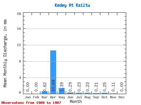
| Statistic | Jan | Feb | Mar | Apr | May | Jun | Jul | Aug | Sep | Oct | Nov | Dec | Annual |
|---|---|---|---|---|---|---|---|---|---|---|---|---|---|
| Mean | 0.00 | 0.00 | 0.62 | 10.64 | 1.39 | 0.29 | 0.23 | 0.23 | 0.21 | 0.25 | 0.11 | 0.00 | 16.31 |
| Standard Deviation | 0.00 | 0.00 | 0.67 | 9.46 | 1.55 | 0.22 | 0.24 | 0.27 | 0.26 | 0.29 | 0.17 | 0.00 | |
| Min | 0.00 | 0.00 | 0.00 | 0.27 | 0.49 | 0.09 | 0.03 | 0.00 | 0.03 | 0.03 | 0.01 | 0.00 | 16.31 |
| Max | 0.00 | 0.00 | 1.49 | 28.91 | 4.93 | 0.80 | 0.77 | 0.77 | 0.78 | 0.88 | 0.48 | 0.00 | 16.31 |
| Coefficient of Variation | 1.08 | 0.89 | 1.11 | 0.75 | 1.06 | 1.19 | 1.24 | 1.15 | 1.48 | 1.73 |
 Return to R-Arctic Net Home Page