|
|
|||||||||||||||||
| Point ID: 7132 | Downloads | Plots | Site Data | Code: 11616 |
|
|
|||||||||||||||||
| Download | |
|---|---|
| Site Descriptor Information | Site Time Series Data |
| Link to all available data | |
| View: | Time Series | All |
| Units: | m3/s |
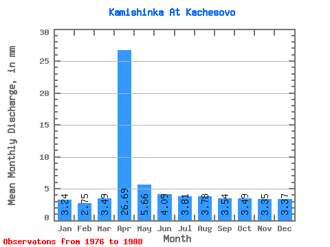
| Statistic | Jan | Feb | Mar | Apr | May | Jun | Jul | Aug | Sep | Oct | Nov | Dec | Annual |
|---|---|---|---|---|---|---|---|---|---|---|---|---|---|
| Mean | 3.23 | 2.77 | 3.48 | 26.69 | 5.67 | 4.09 | 3.81 | 3.79 | 3.54 | 3.48 | 3.34 | 3.37 | 68.77 |
| Standard Deviation | 0.89 | 0.63 | 0.97 | 17.73 | 2.50 | 1.03 | 1.28 | 1.00 | 1.14 | 1.14 | 0.47 | 1.01 | 21.32 |
| Min | 1.81 | 1.62 | 1.91 | 7.69 | 3.81 | 2.09 | 1.65 | 2.67 | 1.57 | 0.95 | 2.46 | 1.97 | 42.18 |
| Max | 5.40 | 3.76 | 5.40 | 66.72 | 11.75 | 6.15 | 6.04 | 6.35 | 5.84 | 4.76 | 4.00 | 6.04 | 106.42 |
| Coefficient of Variation | 0.27 | 0.23 | 0.28 | 0.66 | 0.44 | 0.25 | 0.34 | 0.26 | 0.32 | 0.33 | 0.14 | 0.30 | 0.31 |
 Return to R-Arctic Net Home Page