|
|
|||||||||||||||||
| Point ID: 7130 | Downloads | Plots | Site Data | Code: 11613 |
|
|
|||||||||||||||||
| Download | |
|---|---|
| Site Descriptor Information | Site Time Series Data |
| Link to all available data | |
| View: | Time Series | All |
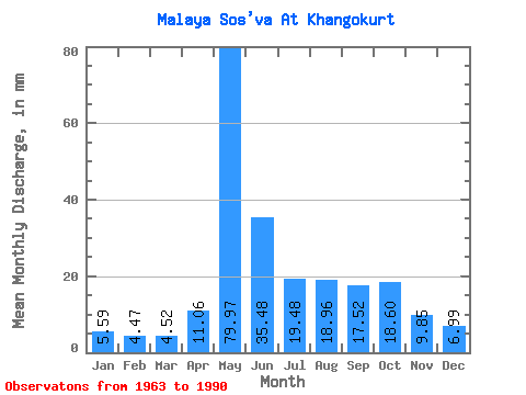
| Units: | m3/s |
| Statistic | Jan | Feb | Mar | Apr | May | Jun | Jul | Aug | Sep | Oct | Nov | Dec | Annual |
|---|---|---|---|---|---|---|---|---|---|---|---|---|---|
| Mean | 5.59 | 4.51 | 4.52 | 11.06 | 79.96 | 35.48 | 19.47 | 18.96 | 17.52 | 18.59 | 9.85 | 6.99 | 230.41 |
| Standard Deviation | 1.27 | 1.10 | 1.38 | 7.94 | 28.98 | 17.38 | 11.38 | 14.71 | 6.89 | 9.62 | 3.96 | 1.46 | 55.54 |
| Min | 2.83 | 1.46 | 0.62 | 5.02 | 32.15 | 14.84 | 10.62 | 8.38 | 7.99 | 6.02 | 5.54 | 4.86 | 159.03 |
| Max | 7.43 | 5.80 | 5.76 | 31.63 | 125.64 | 63.37 | 52.03 | 53.32 | 34.08 | 37.28 | 19.41 | 10.38 | 317.77 |
| Coefficient of Variation | 0.23 | 0.24 | 0.30 | 0.72 | 0.36 | 0.49 | 0.58 | 0.78 | 0.39 | 0.52 | 0.40 | 0.21 | 0.24 |
 Return to R-Arctic Net Home Page