|
|
|||||||||||||||||
| Point ID: 7115 | Downloads | Plots | Site Data | Code: 11568 |
|
|
|||||||||||||||||
| Download | |
|---|---|
| Site Descriptor Information | Site Time Series Data |
| Link to all available data | |
| View: | Time Series | All |
| Units: | m3/s |
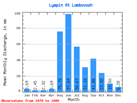
| Statistic | Jan | Feb | Mar | Apr | May | Jun | Jul | Aug | Sep | Oct | Nov | Dec | Annual |
|---|---|---|---|---|---|---|---|---|---|---|---|---|---|
| Mean | 3.69 | 2.47 | 2.31 | 3.69 | 75.74 | 97.64 | 56.66 | 31.15 | 41.86 | 23.91 | 10.50 | 6.28 | 354.70 |
| Standard Deviation | 1.23 | 0.72 | 0.60 | 3.48 | 31.58 | 31.64 | 17.05 | 11.06 | 20.45 | 9.33 | 5.02 | 3.00 | 56.35 |
| Min | 1.67 | 0.98 | 1.13 | 1.23 | 33.17 | 40.33 | 34.57 | 15.59 | 14.70 | 10.59 | 5.35 | 3.75 | 223.34 |
| Max | 6.63 | 3.21 | 3.12 | 14.89 | 123.91 | 143.14 | 87.83 | 48.26 | 77.57 | 42.67 | 22.63 | 14.99 | 463.34 |
| Coefficient of Variation | 0.33 | 0.29 | 0.26 | 0.94 | 0.42 | 0.32 | 0.30 | 0.35 | 0.49 | 0.39 | 0.48 | 0.48 | 0.16 |
 Return to R-Arctic Net Home Page