|
|
|||||||||||||||||
| Point ID: 7114 | Downloads | Plots | Site Data | Code: 11564 |
|
|
|||||||||||||||||
| Download | |
|---|---|
| Site Descriptor Information | Site Time Series Data |
| Link to all available data | |
| View: | Time Series | All |
| Units: | m3/s |
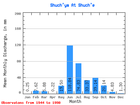
| Statistic | Jan | Feb | Mar | Apr | May | Jun | Jul | Aug | Sep | Oct | Nov | Dec | Annual |
|---|---|---|---|---|---|---|---|---|---|---|---|---|---|
| Mean | 0.25 | 7.69 | 5.88 | 0.22 | 19.50 | 118.84 | 74.82 | 33.36 | 39.14 | 20.14 | 4.83 | 1.30 | 310.32 |
| Standard Deviation | 0.39 | 24.15 | 15.56 | 0.50 | 19.89 | 30.59 | 31.68 | 19.58 | 21.60 | 8.33 | 3.58 | 1.13 | 44.51 |
| Min | 0.00 | 0.00 | 0.00 | 0.00 | 0.07 | 63.09 | 0.04 | 12.23 | 12.94 | 6.37 | 0.68 | 0.17 | 264.36 |
| Max | 1.45 | 76.42 | 41.18 | 1.11 | 75.54 | 188.29 | 125.06 | 86.91 | 88.03 | 34.36 | 19.17 | 4.85 | 353.21 |
| Coefficient of Variation | 1.54 | 3.14 | 2.65 | 2.24 | 1.02 | 0.26 | 0.42 | 0.59 | 0.55 | 0.41 | 0.74 | 0.87 | 0.14 |
 Return to R-Arctic Net Home Page