|
|
|||||||||||||||||
| Point ID: 7113 | Downloads | Plots | Site Data | Code: 11563 |
|
|
|||||||||||||||||
| Download | |
|---|---|
| Site Descriptor Information | Site Time Series Data |
| Link to all available data | |
| View: | Time Series | All |
| Units: | m3/s |
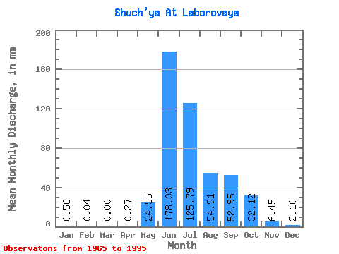
| Statistic | Jan | Feb | Mar | Apr | May | Jun | Jul | Aug | Sep | Oct | Nov | Dec | Annual |
|---|---|---|---|---|---|---|---|---|---|---|---|---|---|
| Mean | 0.56 | 0.04 | 0.00 | 0.27 | 24.54 | 178.03 | 125.78 | 54.90 | 52.95 | 32.12 | 6.45 | 2.10 | 493.61 |
| Standard Deviation | 0.66 | 0.09 | 0.00 | 0.47 | 31.18 | 55.75 | 46.89 | 24.13 | 25.55 | 19.18 | 3.85 | 1.39 | 24.47 |
| Min | 0.00 | 0.00 | 0.00 | 0.00 | 0.16 | 109.70 | 15.43 | 23.43 | 23.45 | 9.90 | 1.37 | 0.19 | 464.05 |
| Max | 1.72 | 0.22 | 0.00 | 1.20 | 91.18 | 317.83 | 232.73 | 97.24 | 103.06 | 76.51 | 13.22 | 4.70 | 516.68 |
| Coefficient of Variation | 1.17 | 1.94 | 1.77 | 1.27 | 0.31 | 0.37 | 0.44 | 0.48 | 0.60 | 0.60 | 0.66 | 0.05 |
 Return to R-Arctic Net Home Page