|
|
|||||||||||||||||
| Point ID: 7108 | Downloads | Plots | Site Data | Code: 11550 |
|
|
|||||||||||||||||
| Download | |
|---|---|
| Site Descriptor Information | Site Time Series Data |
| Link to all available data | |
| View: | Time Series | All |
| Units: | m3/s |
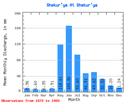
| Statistic | Jan | Feb | Mar | Apr | May | Jun | Jul | Aug | Sep | Oct | Nov | Dec | Annual |
|---|---|---|---|---|---|---|---|---|---|---|---|---|---|
| Mean | 8.96 | 6.66 | 6.35 | 7.91 | 118.59 | 165.81 | 93.59 | 46.90 | 49.62 | 32.53 | 16.20 | 11.24 | 561.51 |
| Standard Deviation | 1.98 | 1.10 | 1.30 | 2.51 | 80.86 | 67.97 | 78.46 | 19.85 | 16.38 | 13.16 | 4.51 | 2.36 | 175.38 |
| Min | 5.00 | 4.87 | 3.77 | 3.11 | 15.98 | 70.17 | 17.02 | 23.38 | 24.06 | 14.80 | 8.23 | 7.34 | 305.10 |
| Max | 13.97 | 8.86 | 8.48 | 13.25 | 269.28 | 264.93 | 318.11 | 88.48 | 88.21 | 62.44 | 27.50 | 18.20 | 906.29 |
| Coefficient of Variation | 0.22 | 0.17 | 0.20 | 0.32 | 0.68 | 0.41 | 0.84 | 0.42 | 0.33 | 0.41 | 0.28 | 0.21 | 0.31 |
 Return to R-Arctic Net Home Page