|
|
|||||||||||||||||
| Point ID: 7098 | Downloads | Plots | Site Data | Code: 11536 |
|
|
|||||||||||||||||
| Download | |
|---|---|
| Site Descriptor Information | Site Time Series Data |
| Link to all available data | |
| View: | Time Series | All |
| Units: | m3/s |
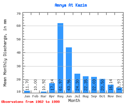
| Statistic | Jan | Feb | Mar | Apr | May | Jun | Jul | Aug | Sep | Oct | Nov | Dec | Annual |
|---|---|---|---|---|---|---|---|---|---|---|---|---|---|
| Mean | 11.70 | 10.09 | 10.92 | 17.14 | 61.96 | 43.96 | 24.29 | 22.35 | 22.03 | 20.49 | 16.14 | 13.97 | 274.61 |
| Standard Deviation | 1.57 | 1.30 | 1.33 | 11.15 | 19.50 | 23.93 | 8.19 | 9.68 | 5.84 | 5.69 | 4.29 | 3.23 | 39.72 |
| Min | 9.05 | 8.08 | 7.51 | 7.81 | 16.86 | 16.06 | 14.11 | 12.64 | 13.87 | 11.92 | 8.18 | 9.28 | 203.66 |
| Max | 14.60 | 12.27 | 13.16 | 55.49 | 105.61 | 122.66 | 46.39 | 60.73 | 43.81 | 31.16 | 26.39 | 23.73 | 361.24 |
| Coefficient of Variation | 0.13 | 0.13 | 0.12 | 0.65 | 0.32 | 0.54 | 0.34 | 0.43 | 0.27 | 0.28 | 0.27 | 0.23 | 0.14 |
 Return to R-Arctic Net Home Page