|
|
|||||||||||||||||
| Point ID: 7096 | Downloads | Plots | Site Data | Code: 11533 |
|
|
|||||||||||||||||
| Download | |
|---|---|
| Site Descriptor Information | Site Time Series Data |
| Link to all available data | |
| View: | Time Series | All |
| Units: | m3/s |
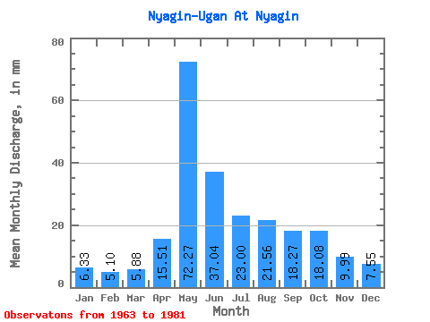
| Statistic | Jan | Feb | Mar | Apr | May | Jun | Jul | Aug | Sep | Oct | Nov | Dec | Annual |
|---|---|---|---|---|---|---|---|---|---|---|---|---|---|
| Mean | 6.33 | 5.14 | 5.88 | 15.51 | 72.26 | 37.04 | 23.00 | 21.56 | 18.27 | 18.08 | 9.99 | 7.55 | 240.70 |
| Standard Deviation | 1.59 | 1.03 | 1.13 | 14.16 | 27.86 | 20.35 | 13.97 | 18.14 | 6.43 | 8.79 | 2.77 | 1.85 | 63.99 |
| Min | 4.41 | 3.02 | 3.49 | 5.35 | 22.62 | 14.75 | 10.32 | 8.62 | 9.73 | 10.04 | 6.32 | 5.01 | 141.84 |
| Max | 11.31 | 7.15 | 7.24 | 61.45 | 116.58 | 81.56 | 60.83 | 86.80 | 29.61 | 36.94 | 15.08 | 13.62 | 401.74 |
| Coefficient of Variation | 0.25 | 0.20 | 0.19 | 0.91 | 0.39 | 0.55 | 0.61 | 0.84 | 0.35 | 0.49 | 0.28 | 0.24 | 0.27 |
 Return to R-Arctic Net Home Page