|
|
|||||||||||||||||
| Point ID: 7089 | Downloads | Plots | Site Data | Code: 11516 |
|
|
|||||||||||||||||
| Download | |
|---|---|
| Site Descriptor Information | Site Time Series Data |
| Link to all available data | |
| View: | Time Series | All |
| Units: | m3/s |
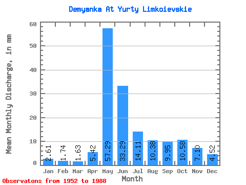
| Statistic | Jan | Feb | Mar | Apr | May | Jun | Jul | Aug | Sep | Oct | Nov | Dec | Annual |
|---|---|---|---|---|---|---|---|---|---|---|---|---|---|
| Mean | 2.61 | 1.76 | 1.63 | 5.42 | 57.28 | 33.30 | 14.10 | 10.38 | 9.95 | 10.58 | 7.10 | 4.51 | 160.18 |
| Standard Deviation | 1.03 | 0.51 | 0.37 | 4.72 | 17.89 | 18.51 | 9.46 | 8.81 | 7.22 | 7.21 | 4.17 | 2.33 | 54.09 |
| Min | 1.10 | 0.94 | 0.96 | 1.26 | 17.59 | 6.87 | 3.48 | 2.79 | 1.66 | 2.39 | 1.44 | 1.18 | 51.30 |
| Max | 5.26 | 2.96 | 2.49 | 20.25 | 84.10 | 90.64 | 45.86 | 35.62 | 29.99 | 30.11 | 17.03 | 10.50 | 299.81 |
| Coefficient of Variation | 0.40 | 0.29 | 0.23 | 0.87 | 0.31 | 0.56 | 0.67 | 0.85 | 0.73 | 0.68 | 0.59 | 0.52 | 0.34 |
 Return to R-Arctic Net Home Page