|
|
|||||||||||||||||
| Point ID: 7087 | Downloads | Plots | Site Data | Code: 11508 |
|
|
|||||||||||||||||
| Download | |
|---|---|
| Site Descriptor Information | Site Time Series Data |
| Link to all available data | |
| View: | Time Series | All |
| Units: | m3/s |
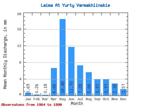
| Statistic | Jan | Feb | Mar | Apr | May | Jun | Jul | Aug | Sep | Oct | Nov | Dec | Annual |
|---|---|---|---|---|---|---|---|---|---|---|---|---|---|
| Mean | 0.69 | 0.26 | 0.17 | 6.66 | 18.48 | 11.70 | 7.27 | 5.66 | 3.97 | 3.97 | 2.92 | 1.57 | 63.92 |
| Standard Deviation | 0.84 | 0.24 | 0.12 | 5.44 | 11.87 | 9.31 | 7.75 | 8.30 | 6.26 | 5.95 | 4.34 | 1.98 | 52.15 |
| Min | 0.04 | 0.02 | 0.03 | 0.59 | 2.92 | 1.62 | 1.17 | 0.36 | 0.13 | 0.13 | 0.11 | 0.06 | 11.97 |
| Max | 3.41 | 0.88 | 0.46 | 20.12 | 40.90 | 33.87 | 33.64 | 42.34 | 31.44 | 27.26 | 20.49 | 9.07 | 235.76 |
| Coefficient of Variation | 1.23 | 0.92 | 0.65 | 0.82 | 0.64 | 0.80 | 1.06 | 1.47 | 1.58 | 1.50 | 1.48 | 1.26 | 0.82 |
 Return to R-Arctic Net Home Page