|
|
|||||||||||||||||
| Point ID: 7085 | Downloads | Plots | Site Data | Code: 11499 |
|
|
|||||||||||||||||
| Download | |
|---|---|
| Site Descriptor Information | Site Time Series Data |
| Link to all available data | |
| View: | Time Series | All |
| Units: | m3/s |
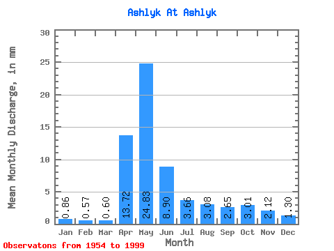
| Statistic | Jan | Feb | Mar | Apr | May | Jun | Jul | Aug | Sep | Oct | Nov | Dec | Annual |
|---|---|---|---|---|---|---|---|---|---|---|---|---|---|
| Mean | 0.86 | 0.58 | 0.60 | 13.72 | 24.82 | 8.90 | 3.66 | 3.08 | 2.65 | 3.01 | 2.12 | 1.30 | 64.98 |
| Standard Deviation | 0.65 | 0.33 | 0.27 | 19.72 | 23.21 | 8.15 | 4.08 | 3.98 | 3.71 | 3.89 | 2.28 | 1.18 | 54.84 |
| Min | 0.22 | 0.15 | 0.19 | 0.71 | 1.07 | 0.39 | 0.22 | 0.24 | 0.16 | 0.23 | 0.20 | 0.26 | 5.78 |
| Max | 3.88 | 1.85 | 1.27 | 118.39 | 105.70 | 41.12 | 23.43 | 20.86 | 23.68 | 21.24 | 11.90 | 7.03 | 262.62 |
| Coefficient of Variation | 0.76 | 0.57 | 0.44 | 1.44 | 0.94 | 0.92 | 1.11 | 1.29 | 1.40 | 1.29 | 1.08 | 0.90 | 0.84 |
 Return to R-Arctic Net Home Page