|
|
|||||||||||||||||
| Point ID: 7079 | Downloads | Plots | Site Data | Code: 11490 |
|
|
|||||||||||||||||
| Download | |
|---|---|
| Site Descriptor Information | Site Time Series Data |
| Link to all available data | |
| View: | Time Series | All |
| Units: | m3/s |
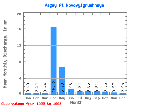
| Statistic | Jan | Feb | Mar | Apr | May | Jun | Jul | Aug | Sep | Oct | Nov | Dec | Annual |
|---|---|---|---|---|---|---|---|---|---|---|---|---|---|
| Mean | 0.40 | 0.34 | 0.44 | 16.43 | 6.73 | 1.47 | 0.84 | 0.85 | 0.81 | 0.75 | 0.57 | 0.45 | 30.15 |
| Standard Deviation | 0.13 | 0.11 | 0.14 | 15.64 | 6.96 | 1.33 | 0.54 | 0.62 | 0.44 | 0.37 | 0.20 | 0.13 | 22.57 |
| Min | 0.16 | 0.13 | 0.15 | 1.50 | 0.86 | 0.09 | 0.02 | 0.09 | 0.28 | 0.32 | 0.27 | 0.20 | 9.37 |
| Max | 0.77 | 0.60 | 0.70 | 82.76 | 31.07 | 6.17 | 2.56 | 2.75 | 1.90 | 2.16 | 1.10 | 0.73 | 126.80 |
| Coefficient of Variation | 0.33 | 0.32 | 0.32 | 0.95 | 1.03 | 0.91 | 0.64 | 0.73 | 0.55 | 0.49 | 0.36 | 0.30 | 0.75 |
 Return to R-Arctic Net Home Page