|
|
|||||||||||||||||
| Point ID: 7074 | Downloads | Plots | Site Data | Code: 11479 |
|
|
|||||||||||||||||
| Download | |
|---|---|
| Site Descriptor Information | Site Time Series Data |
| Link to all available data | |
| View: | Time Series | All |
| Units: | m3/s |
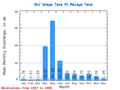
| Statistic | Jan | Feb | Mar | Apr | May | Jun | Jul | Aug | Sep | Oct | Nov | Dec | Annual |
|---|---|---|---|---|---|---|---|---|---|---|---|---|---|
| Mean | 0.79 | 0.58 | 0.59 | 19.61 | 34.12 | 11.25 | 3.93 | 3.49 | 2.79 | 3.72 | 2.34 | 1.08 | 80.56 |
| Standard Deviation | 0.42 | 0.26 | 0.24 | 16.00 | 24.49 | 12.56 | 4.86 | 5.18 | 3.79 | 4.48 | 2.74 | 0.76 | 47.52 |
| Min | 0.33 | 0.18 | 0.17 | 0.82 | 1.22 | 0.71 | 0.55 | 0.57 | 0.42 | 0.42 | 0.41 | 0.33 | 8.76 |
| Max | 2.10 | 1.30 | 1.14 | 61.72 | 102.95 | 65.22 | 25.35 | 18.11 | 21.25 | 18.88 | 15.62 | 3.64 | 173.36 |
| Coefficient of Variation | 0.53 | 0.46 | 0.41 | 0.82 | 0.72 | 1.12 | 1.24 | 1.48 | 1.36 | 1.21 | 1.17 | 0.71 | 0.59 |
 Return to R-Arctic Net Home Page