|
|
|||||||||||||||||
| Point ID: 7073 | Downloads | Plots | Site Data | Code: 11474 |
|
|
|||||||||||||||||
| Download | |
|---|---|
| Site Descriptor Information | Site Time Series Data |
| Link to all available data | |
| View: | Time Series | All |
| Units: | m3/s |
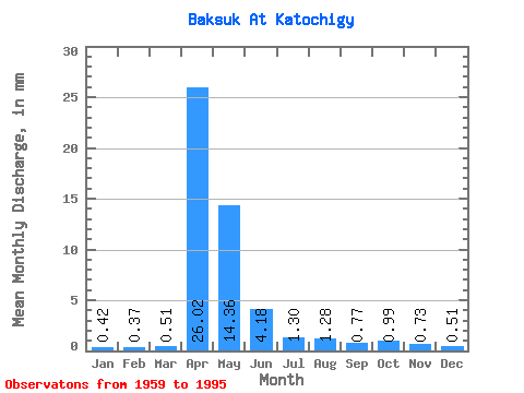
| Statistic | Jan | Feb | Mar | Apr | May | Jun | Jul | Aug | Sep | Oct | Nov | Dec | Annual |
|---|---|---|---|---|---|---|---|---|---|---|---|---|---|
| Mean | 0.42 | 0.37 | 0.51 | 26.02 | 14.36 | 4.18 | 1.30 | 1.28 | 0.77 | 0.99 | 0.73 | 0.51 | 49.70 |
| Standard Deviation | 0.18 | 0.17 | 0.32 | 19.69 | 14.94 | 5.58 | 1.75 | 2.30 | 0.72 | 1.10 | 0.52 | 0.33 | 32.98 |
| Min | 0.13 | 0.12 | 0.10 | 3.50 | 0.65 | 0.22 | 0.12 | 0.03 | 0.10 | 0.19 | 0.17 | 0.14 | 7.09 |
| Max | 0.91 | 1.02 | 1.98 | 76.50 | 56.94 | 26.17 | 7.46 | 10.09 | 3.72 | 4.50 | 2.37 | 1.90 | 113.17 |
| Coefficient of Variation | 0.44 | 0.47 | 0.63 | 0.76 | 1.04 | 1.33 | 1.35 | 1.80 | 0.94 | 1.11 | 0.70 | 0.65 | 0.66 |
 Return to R-Arctic Net Home Page