|
|
|||||||||||||||||
| Point ID: 7071 | Downloads | Plots | Site Data | Code: 11468 |
|
|
|||||||||||||||||
| Download | |
|---|---|
| Site Descriptor Information | Site Time Series Data |
| Link to all available data | |
| View: | Time Series | All |
| Units: | m3/s |
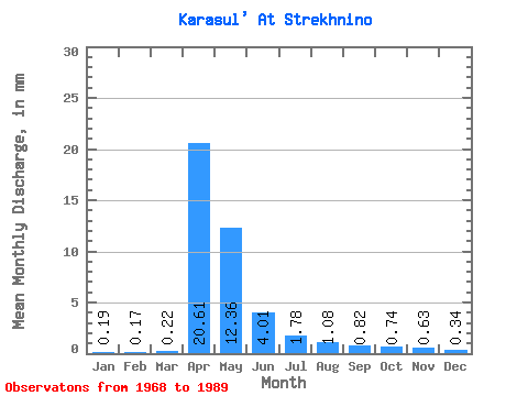
| Statistic | Jan | Feb | Mar | Apr | May | Jun | Jul | Aug | Sep | Oct | Nov | Dec | Annual |
|---|---|---|---|---|---|---|---|---|---|---|---|---|---|
| Mean | 0.19 | 0.17 | 0.22 | 20.61 | 12.36 | 4.01 | 1.78 | 1.08 | 0.82 | 0.74 | 0.64 | 0.34 | 41.88 |
| Standard Deviation | 0.10 | 0.08 | 0.12 | 17.11 | 13.66 | 4.35 | 2.37 | 1.19 | 0.95 | 0.79 | 0.69 | 0.28 | 35.04 |
| Min | 0.02 | 0.07 | 0.09 | 3.57 | 0.28 | 0.01 | 0.01 | 0.00 | 0.03 | 0.05 | 0.04 | 0.04 | 9.48 |
| Max | 0.36 | 0.34 | 0.49 | 63.24 | 54.74 | 15.55 | 7.68 | 3.87 | 3.89 | 3.32 | 2.34 | 1.04 | 117.55 |
| Coefficient of Variation | 0.54 | 0.47 | 0.52 | 0.83 | 1.10 | 1.08 | 1.33 | 1.10 | 1.16 | 1.07 | 1.08 | 0.85 | 0.84 |
 Return to R-Arctic Net Home Page