|
|
|||||||||||||||||
| Point ID: 7069 | Downloads | Plots | Site Data | Code: 11460 |
|
|
|||||||||||||||||
| Download | |
|---|---|
| Site Descriptor Information | Site Time Series Data |
| Link to all available data | |
| View: | Time Series | All |
| Units: | m3/s |
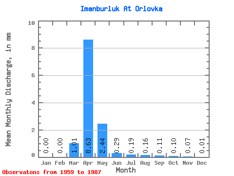
| Statistic | Jan | Feb | Mar | Apr | May | Jun | Jul | Aug | Sep | Oct | Nov | Dec | Annual |
|---|---|---|---|---|---|---|---|---|---|---|---|---|---|
| Mean | 0.00 | 0.00 | 1.01 | 8.63 | 2.44 | 0.29 | 0.19 | 0.16 | 0.11 | 0.10 | 0.07 | 0.01 | |
| Standard Deviation | 0.01 | 0.00 | 1.09 | 5.70 | 2.28 | 0.43 | 0.50 | 0.47 | 0.32 | 0.27 | 0.17 | 0.01 | |
| Min | 0.00 | 0.00 | 0.00 | 0.14 | 0.01 | 0.00 | 0.00 | 0.00 | 0.00 | 0.00 | 0.00 | 0.00 | |
| Max | 0.01 | 0.00 | 2.87 | 20.98 | 9.56 | 1.60 | 1.93 | 1.57 | 1.01 | 0.96 | 0.49 | 0.03 | |
| Coefficient of Variation | 1.73 | 1.07 | 0.66 | 0.93 | 1.48 | 2.63 | 2.88 | 2.88 | 2.75 | 2.57 | 1.54 |
 Return to R-Arctic Net Home Page