|
|
|||||||||||||||||
| Point ID: 7067 | Downloads | Plots | Site Data | Code: 11455 |
|
|
|||||||||||||||||
| Download | |
|---|---|
| Site Descriptor Information | Site Time Series Data |
| Link to all available data | |
| View: | Time Series | All |
| Units: | m3/s |
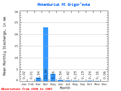
| Statistic | Jan | Feb | Mar | Apr | May | Jun | Jul | Aug | Sep | Oct | Nov | Dec | Annual |
|---|---|---|---|---|---|---|---|---|---|---|---|---|---|
| Mean | 0.02 | 0.01 | 1.38 | 20.53 | 2.82 | 0.48 | 0.37 | 0.26 | 0.17 | 0.22 | 0.14 | 0.05 | |
| Standard Deviation | 0.02 | 0.01 | 3.46 | 12.50 | 2.34 | 0.42 | 0.40 | 0.38 | 0.12 | 0.08 | 0.07 | 0.05 | |
| Min | 0.00 | 0.00 | 0.00 | 3.72 | 0.34 | 0.04 | 0.02 | 0.00 | 0.01 | 0.06 | 0.02 | 0.00 | |
| Max | 0.05 | 0.03 | 12.61 | 48.50 | 9.86 | 1.86 | 1.96 | 1.96 | 0.60 | 0.44 | 0.33 | 0.21 | |
| Coefficient of Variation | 1.08 | 1.73 | 2.51 | 0.61 | 0.83 | 0.88 | 1.08 | 1.46 | 0.70 | 0.39 | 0.52 | 1.08 |
 Return to R-Arctic Net Home Page