|
|
|||||||||||||||||
| Point ID: 7064 | Downloads | Plots | Site Data | Code: 11433 |
|
|
|||||||||||||||||
| Download | |
|---|---|
| Site Descriptor Information | Site Time Series Data |
| Link to all available data | |
| View: | Time Series | All |
| Units: | m3/s |
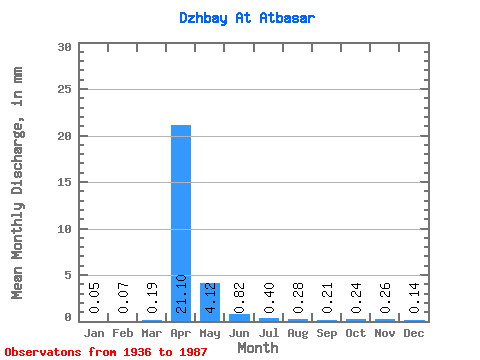
| Statistic | Jan | Feb | Mar | Apr | May | Jun | Jul | Aug | Sep | Oct | Nov | Dec | Annual |
|---|---|---|---|---|---|---|---|---|---|---|---|---|---|
| Mean | 0.05 | 0.07 | 0.18 | 21.10 | 4.12 | 0.82 | 0.40 | 0.28 | 0.21 | 0.24 | 0.26 | 0.14 | 45.44 |
| Standard Deviation | 0.07 | 0.09 | 0.48 | 17.01 | 4.25 | 0.89 | 0.39 | 0.35 | 0.19 | 0.18 | 0.23 | 0.17 | 23.53 |
| Min | 0.00 | 0.00 | 0.00 | 0.95 | 0.65 | 0.09 | 0.03 | 0.01 | 0.01 | 0.02 | 0.01 | 0.00 | 21.07 |
| Max | 0.25 | 0.23 | 2.40 | 86.60 | 21.44 | 4.22 | 1.77 | 2.28 | 0.78 | 0.65 | 0.99 | 0.72 | 101.55 |
| Coefficient of Variation | 1.40 | 1.20 | 2.59 | 0.81 | 1.03 | 1.08 | 0.98 | 1.27 | 0.91 | 0.74 | 0.89 | 1.17 | 0.52 |
 Return to R-Arctic Net Home Page