|
|
|||||||||||||||||
| Point ID: 7048 | Downloads | Plots | Site Data | Code: 11397 |
|
|
|||||||||||||||||
| Download | |
|---|---|
| Site Descriptor Information | Site Time Series Data |
| Link to all available data | |
| View: | Time Series | All |
| Units: | m3/s |
| Statistic | Jan | Feb | Mar | Apr | May | Jun | Jul | Aug | Sep | Oct | Nov | Dec | Annual |
|---|---|---|---|---|---|---|---|---|---|---|---|---|---|
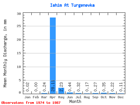
| Mean | 0.02 | 0.00 | 0.24 | 28.11 | 2.23 | 0.44 | 0.32 | 0.17 | 0.27 | 0.35 | 0.22 | 0.11 | 57.36 |
| Standard Deviation | 0.03 | 0.00 | 0.24 | 16.39 | 2.50 | 0.40 | 0.63 | 0.18 | 0.19 | 0.17 | 0.17 | 0.09 | |
| Min | 0.00 | 0.00 | 0.00 | 5.87 | 0.57 | 0.06 | 0.01 | 0.00 | 0.06 | 0.05 | 0.01 | 0.00 | 57.36 |
| Max | 0.06 | 0.00 | 0.69 | 51.92 | 10.00 | 1.53 | 2.36 | 0.61 | 0.62 | 0.54 | 0.50 | 0.26 | 57.36 |
| Coefficient of Variation | 1.33 | 1.02 | 0.58 | 1.12 | 0.91 | 1.97 | 1.07 | 0.69 | 0.48 | 0.80 | 0.85 |
 Return to R-Arctic Net Home Page