|
|
|||||||||||||||||
| Point ID: 7044 | Downloads | Plots | Site Data | Code: 11385 |
|
|
|||||||||||||||||
| Download | |
|---|---|
| Site Descriptor Information | Site Time Series Data |
| Link to all available data | |
| View: | Time Series | All |
| Units: | m3/s |
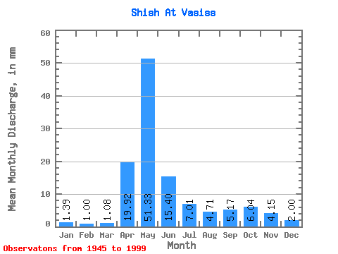
| Statistic | Jan | Feb | Mar | Apr | May | Jun | Jul | Aug | Sep | Oct | Nov | Dec | Annual |
|---|---|---|---|---|---|---|---|---|---|---|---|---|---|
| Mean | 1.39 | 1.01 | 1.08 | 19.92 | 51.32 | 15.40 | 7.01 | 4.71 | 5.17 | 6.04 | 4.15 | 2.00 | 118.18 |
| Standard Deviation | 0.56 | 0.35 | 0.37 | 15.52 | 29.99 | 13.10 | 7.68 | 4.37 | 4.71 | 4.72 | 3.56 | 1.00 | 50.38 |
| Min | 0.37 | 0.25 | 0.34 | 1.24 | 3.89 | 1.83 | 1.04 | 1.02 | 1.08 | 1.29 | 0.97 | 0.60 | 25.86 |
| Max | 3.36 | 1.95 | 1.98 | 60.33 | 114.05 | 64.02 | 36.01 | 25.74 | 24.47 | 21.93 | 14.86 | 5.21 | 240.16 |
| Coefficient of Variation | 0.40 | 0.35 | 0.34 | 0.78 | 0.58 | 0.85 | 1.10 | 0.93 | 0.91 | 0.78 | 0.86 | 0.50 | 0.43 |
 Return to R-Arctic Net Home Page