|
|
|||||||||||||||||
| Point ID: 7043 | Downloads | Plots | Site Data | Code: 11384 |
|
|
|||||||||||||||||
| Download | |
|---|---|
| Site Descriptor Information | Site Time Series Data |
| Link to all available data | |
| View: | Time Series | All |
| Units: | m3/s |
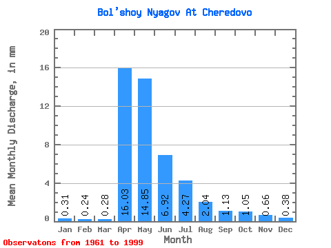
| Statistic | Jan | Feb | Mar | Apr | May | Jun | Jul | Aug | Sep | Oct | Nov | Dec | Annual |
|---|---|---|---|---|---|---|---|---|---|---|---|---|---|
| Mean | 0.31 | 0.24 | 0.28 | 16.03 | 14.84 | 6.92 | 4.27 | 2.04 | 1.13 | 1.05 | 0.66 | 0.38 | 46.90 |
| Standard Deviation | 0.21 | 0.19 | 0.18 | 15.30 | 14.87 | 9.97 | 9.21 | 3.98 | 1.74 | 1.33 | 0.70 | 0.29 | 41.00 |
| Min | 0.05 | 0.01 | 0.01 | 0.47 | 0.19 | 0.14 | 0.01 | 0.10 | 0.10 | 0.12 | 0.10 | 0.02 | 1.67 |
| Max | 0.83 | 0.76 | 0.83 | 56.74 | 61.83 | 47.75 | 48.69 | 16.30 | 8.96 | 6.41 | 2.85 | 1.15 | 153.06 |
| Coefficient of Variation | 0.69 | 0.79 | 0.64 | 0.95 | 1.00 | 1.44 | 2.15 | 1.95 | 1.55 | 1.27 | 1.07 | 0.76 | 0.87 |
 Return to R-Arctic Net Home Page