|
|
|||||||||||||||||
| Point ID: 7037 | Downloads | Plots | Site Data | Code: 11370 |
|
|
|||||||||||||||||
| Download | |
|---|---|
| Site Descriptor Information | Site Time Series Data |
| Link to all available data | |
| View: | Time Series | All |
| Units: | m3/s |
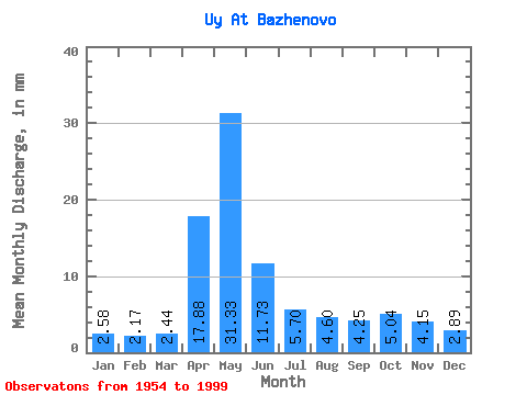
| Statistic | Jan | Feb | Mar | Apr | May | Jun | Jul | Aug | Sep | Oct | Nov | Dec | Annual |
|---|---|---|---|---|---|---|---|---|---|---|---|---|---|
| Mean | 2.58 | 2.19 | 2.44 | 17.88 | 31.33 | 11.73 | 5.70 | 4.60 | 4.25 | 5.04 | 4.15 | 2.89 | 94.33 |
| Standard Deviation | 0.53 | 0.45 | 0.48 | 11.19 | 16.48 | 7.51 | 4.00 | 2.97 | 2.01 | 2.49 | 2.10 | 0.77 | 34.45 |
| Min | 1.41 | 1.22 | 1.56 | 2.32 | 3.96 | 2.74 | 2.11 | 2.20 | 1.93 | 2.22 | 1.74 | 1.64 | 33.86 |
| Max | 3.83 | 3.42 | 3.77 | 51.06 | 71.68 | 38.90 | 20.90 | 20.05 | 11.73 | 13.41 | 13.76 | 5.88 | 182.51 |
| Coefficient of Variation | 0.20 | 0.20 | 0.20 | 0.63 | 0.53 | 0.64 | 0.70 | 0.65 | 0.47 | 0.49 | 0.51 | 0.27 | 0.36 |
 Return to R-Arctic Net Home Page