|
|
|||||||||||||||||
| Point ID: 7024 | Downloads | Plots | Site Data | Code: 11340 |
|
|
|||||||||||||||||
| Download | |
|---|---|
| Site Descriptor Information | Site Time Series Data |
| Link to all available data | |
| View: | Time Series | All |
| Units: | m3/s |
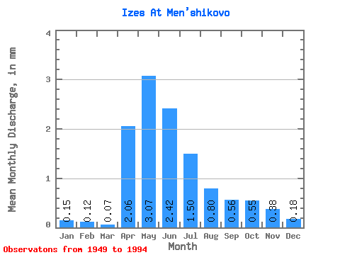
| Statistic | Jan | Feb | Mar | Apr | May | Jun | Jul | Aug | Sep | Oct | Nov | Dec | Annual |
|---|---|---|---|---|---|---|---|---|---|---|---|---|---|
| Mean | 0.15 | 0.12 | 0.07 | 2.06 | 3.07 | 2.42 | 1.50 | 0.80 | 0.56 | 0.55 | 0.38 | 0.18 | 20.98 |
| Standard Deviation | 0.29 | 0.21 | 0.11 | 1.74 | 3.93 | 3.45 | 2.21 | 1.03 | 0.68 | 0.79 | 0.61 | 0.33 | 18.72 |
| Min | 0.00 | 0.00 | 0.00 | 0.05 | 0.01 | 0.01 | 0.01 | 0.00 | 0.00 | 0.00 | 0.00 | 0.00 | 1.72 |
| Max | 0.96 | 0.71 | 0.35 | 8.61 | 18.60 | 15.43 | 9.35 | 3.90 | 2.54 | 3.10 | 2.31 | 1.34 | 61.14 |
| Coefficient of Variation | 1.88 | 1.74 | 1.60 | 0.84 | 1.28 | 1.43 | 1.47 | 1.28 | 1.22 | 1.45 | 1.61 | 1.81 | 0.89 |
 Return to R-Arctic Net Home Page