|
|
|||||||||||||||||
| Point ID: 7018 | Downloads | Plots | Site Data | Code: 11332 |
|
|
|||||||||||||||||
| Download | |
|---|---|
| Site Descriptor Information | Site Time Series Data |
| Link to all available data | |
| View: | Time Series | All |
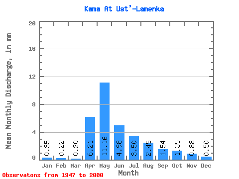
| Units: | m3/s |
| Statistic | Jan | Feb | Mar | Apr | May | Jun | Jul | Aug | Sep | Oct | Nov | Dec | Annual |
|---|---|---|---|---|---|---|---|---|---|---|---|---|---|
| Mean | 0.35 | 0.23 | 0.20 | 6.21 | 11.16 | 4.98 | 3.50 | 2.44 | 1.54 | 1.35 | 0.88 | 0.50 | 38.11 |
| Standard Deviation | 0.38 | 0.25 | 0.22 | 5.69 | 12.24 | 6.60 | 4.85 | 3.16 | 1.91 | 1.71 | 1.09 | 0.53 | 34.32 |
| Min | 0.01 | 0.01 | 0.01 | 0.31 | 0.36 | 0.07 | 0.01 | 0.00 | 0.08 | 0.06 | 0.03 | 0.02 | 4.19 |
| Max | 1.66 | 1.31 | 1.03 | 27.49 | 51.01 | 30.07 | 25.74 | 15.30 | 10.02 | 8.23 | 5.03 | 2.58 | 137.25 |
| Coefficient of Variation | 1.08 | 1.12 | 1.08 | 0.92 | 1.10 | 1.32 | 1.39 | 1.29 | 1.24 | 1.26 | 1.24 | 1.04 | 0.90 |
 Return to R-Arctic Net Home Page