|
|
|||||||||||||||||
| Point ID: 7016 | Downloads | Plots | Site Data | Code: 11327 |
|
|
|||||||||||||||||
| Download | |
|---|---|
| Site Descriptor Information | Site Time Series Data |
| Link to all available data | |
| View: | Time Series | All |
| Units: | m3/s |
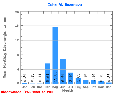
| Statistic | Jan | Feb | Mar | Apr | May | Jun | Jul | Aug | Sep | Oct | Nov | Dec | Annual |
|---|---|---|---|---|---|---|---|---|---|---|---|---|---|
| Mean | 0.24 | 0.13 | 0.11 | 5.61 | 15.65 | 6.94 | 3.10 | 1.65 | 1.15 | 1.14 | 0.72 | 0.39 | 48.23 |
| Standard Deviation | 0.22 | 0.11 | 0.09 | 5.06 | 14.25 | 9.19 | 4.97 | 2.21 | 1.50 | 1.38 | 0.80 | 0.43 | 38.26 |
| Min | 0.00 | 0.00 | 0.00 | 0.04 | 0.27 | 0.02 | 0.03 | 0.03 | 0.04 | 0.03 | 0.01 | 0.01 | 1.76 |
| Max | 0.73 | 0.37 | 0.34 | 22.55 | 54.24 | 38.59 | 26.10 | 11.31 | 7.06 | 5.46 | 3.32 | 1.81 | 138.31 |
| Coefficient of Variation | 0.93 | 0.85 | 0.78 | 0.90 | 0.91 | 1.32 | 1.60 | 1.34 | 1.30 | 1.22 | 1.11 | 1.11 | 0.79 |
 Return to R-Arctic Net Home Page