|
|
|||||||||||||||||
| Point ID: 7012 | Downloads | Plots | Site Data | Code: 11314 |
|
|
|||||||||||||||||
| Download | |
|---|---|
| Site Descriptor Information | Site Time Series Data |
| Link to all available data | |
| View: | Time Series | All |
| Units: | m3/s |
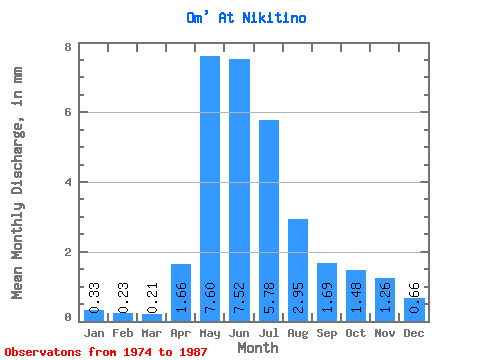
| Statistic | Jan | Feb | Mar | Apr | May | Jun | Jul | Aug | Sep | Oct | Nov | Dec | Annual |
|---|---|---|---|---|---|---|---|---|---|---|---|---|---|
| Mean | 0.33 | 0.23 | 0.21 | 1.66 | 7.59 | 7.53 | 5.78 | 2.95 | 1.69 | 1.48 | 1.26 | 0.66 | 32.07 |
| Standard Deviation | 0.39 | 0.24 | 0.18 | 0.85 | 3.30 | 6.15 | 7.74 | 4.80 | 2.90 | 2.06 | 1.56 | 0.76 | 28.53 |
| Min | 0.04 | 0.02 | 0.04 | 0.10 | 1.84 | 0.27 | 0.03 | 0.01 | 0.11 | 0.20 | 0.15 | 0.12 | 3.83 |
| Max | 1.45 | 0.89 | 0.70 | 3.15 | 12.63 | 18.34 | 22.60 | 15.19 | 10.61 | 7.41 | 5.20 | 2.83 | 89.73 |
| Coefficient of Variation | 1.16 | 1.04 | 0.88 | 0.51 | 0.43 | 0.82 | 1.34 | 1.63 | 1.71 | 1.39 | 1.24 | 1.16 | 0.89 |
 Return to R-Arctic Net Home Page