|
|
|||||||||||||||||
| Point ID: 7009 | Downloads | Plots | Site Data | Code: 11309 |
|
|
|||||||||||||||||
| Download | |
|---|---|
| Site Descriptor Information | Site Time Series Data |
| Link to all available data | |
| View: | Time Series | All |
| Units: | m3/s |
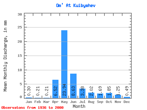
| Statistic | Jan | Feb | Mar | Apr | May | Jun | Jul | Aug | Sep | Oct | Nov | Dec | Annual |
|---|---|---|---|---|---|---|---|---|---|---|---|---|---|
| Mean | 0.30 | 0.21 | 0.21 | 6.52 | 23.94 | 8.63 | 3.38 | 2.02 | 1.69 | 1.85 | 1.25 | 0.49 | 47.56 |
| Standard Deviation | 0.24 | 0.15 | 0.14 | 6.21 | 18.37 | 10.57 | 5.01 | 3.12 | 2.66 | 2.77 | 1.59 | 0.52 | 36.77 |
| Min | 0.05 | 0.03 | 0.04 | 0.56 | 0.76 | 0.16 | 0.06 | 0.04 | 0.01 | 0.02 | 0.05 | 0.07 | 3.67 |
| Max | 1.12 | 0.91 | 0.92 | 35.91 | 75.51 | 64.59 | 30.07 | 15.19 | 12.60 | 14.22 | 5.76 | 2.81 | 146.18 |
| Coefficient of Variation | 0.80 | 0.74 | 0.66 | 0.95 | 0.77 | 1.23 | 1.48 | 1.54 | 1.57 | 1.50 | 1.27 | 1.07 | 0.77 |
 Return to R-Arctic Net Home Page