|
|
|||||||||||||||||
| Point ID: 700 | Downloads | Plots | Site Data | Code: 07CE004 |
|
|
|||||||||||||||||
| Download | |
|---|---|
| Site Descriptor Information | Site Time Series Data |
| Link to all available data | |
| View: | Time Series | All |
| Units: | m3/s |
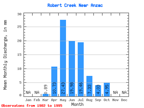
| Statistic | Jan | Feb | Mar | Apr | May | Jun | Jul | Aug | Sep | Oct | Nov | Dec | Annual |
|---|---|---|---|---|---|---|---|---|---|---|---|---|---|
| Mean | 0.91 | 10.73 | 27.44 | 19.98 | 19.45 | 7.33 | 4.00 | 4.98 | |||||
| Standard Deviation | 1.01 | 4.66 | 26.08 | 12.55 | 16.54 | 6.77 | 2.93 | 2.73 | |||||
| Min | 0.00 | 3.98 | 7.92 | 4.17 | 1.58 | 0.59 | 0.86 | 2.28 | |||||
| Max | 3.32 | 19.17 | 87.63 | 43.70 | 54.96 | 22.53 | 11.40 | 9.36 | |||||
| Coefficient of Variation | 1.11 | 0.43 | 0.95 | 0.63 | 0.85 | 0.92 | 0.73 | 0.55 |
 Return to R-Arctic Net Home Page