|
|
|||||||||||||||||
| Point ID: 6994 | Downloads | Plots | Site Data | Code: 11237 |
|
|
|||||||||||||||||
| Download | |
|---|---|
| Site Descriptor Information | Site Time Series Data |
| Link to all available data | |
| View: | Time Series | All |
| Units: | m3/s |
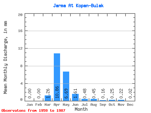
| Statistic | Jan | Feb | Mar | Apr | May | Jun | Jul | Aug | Sep | Oct | Nov | Dec | Annual |
|---|---|---|---|---|---|---|---|---|---|---|---|---|---|
| Mean | 0.00 | 0.00 | 1.26 | 10.86 | 6.69 | 1.61 | 0.48 | 0.45 | 0.16 | 0.25 | 0.22 | 0.02 | 8.07 |
| Standard Deviation | 0.00 | 0.00 | 1.48 | 8.92 | 6.32 | 1.81 | 0.73 | 1.32 | 0.26 | 0.31 | 0.27 | 0.03 | |
| Min | 0.00 | 0.00 | 0.00 | 0.52 | 0.29 | 0.08 | 0.00 | 0.00 | 0.00 | 0.00 | 0.00 | 0.00 | 8.07 |
| Max | 0.00 | 0.00 | 4.42 | 37.58 | 29.46 | 9.54 | 3.27 | 6.00 | 1.09 | 1.26 | 1.04 | 0.07 | 8.07 |
| Coefficient of Variation | 1.18 | 0.82 | 0.95 | 1.13 | 1.51 | 2.96 | 1.62 | 1.26 | 1.27 | 1.34 |
 Return to R-Arctic Net Home Page