|
|
|||||||||||||||||
| Point ID: 6993 | Downloads | Plots | Site Data | Code: 11236 |
|
|
|||||||||||||||||
| Download | |
|---|---|
| Site Descriptor Information | Site Time Series Data |
| Link to all available data | |
| View: | Time Series | All |
| Units: | m3/s |
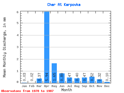
| Statistic | Jan | Feb | Mar | Apr | May | Jun | Jul | Aug | Sep | Oct | Nov | Dec | Annual |
|---|---|---|---|---|---|---|---|---|---|---|---|---|---|
| Mean | 0.03 | 0.01 | 0.37 | 5.94 | 1.65 | 0.80 | 0.47 | 0.40 | 0.47 | 0.52 | 0.32 | 0.10 | 14.37 |
| Standard Deviation | 0.02 | 0.03 | 0.60 | 4.73 | 1.53 | 0.71 | 0.37 | 0.32 | 0.49 | 0.32 | 0.12 | 0.08 | 9.42 |
| Min | 0.00 | 0.00 | 0.00 | 1.22 | 0.13 | 0.05 | 0.02 | 0.02 | 0.00 | 0.05 | 0.04 | 0.01 | 7.71 |
| Max | 0.06 | 0.04 | 1.43 | 15.63 | 4.56 | 1.79 | 1.13 | 0.97 | 1.71 | 1.06 | 0.45 | 0.23 | 21.03 |
| Coefficient of Variation | 0.69 | 1.68 | 1.64 | 0.80 | 0.93 | 0.89 | 0.79 | 0.80 | 1.03 | 0.62 | 0.38 | 0.77 | 0.66 |
 Return to R-Arctic Net Home Page