|
|
|||||||||||||||||
| Point ID: 6985 | Downloads | Plots | Site Data | Code: 11189 |
|
|
|||||||||||||||||
| Download | |
|---|---|
| Site Descriptor Information | Site Time Series Data |
| Link to all available data | |
| View: | Time Series | All |
| Units: | m3/s |
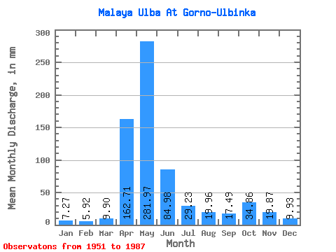
| Statistic | Jan | Feb | Mar | Apr | May | Jun | Jul | Aug | Sep | Oct | Nov | Dec | Annual |
|---|---|---|---|---|---|---|---|---|---|---|---|---|---|
| Mean | 7.27 | 5.97 | 9.90 | 162.71 | 281.92 | 84.98 | 29.23 | 19.95 | 17.49 | 34.86 | 19.87 | 9.93 | 686.14 |
| Standard Deviation | 2.08 | 1.46 | 5.39 | 56.86 | 119.27 | 66.12 | 20.30 | 16.95 | 12.98 | 27.89 | 10.57 | 4.10 | 191.81 |
| Min | 3.33 | 4.18 | 5.08 | 75.49 | 101.32 | 13.38 | 6.43 | 4.89 | 4.68 | 9.72 | 6.76 | 4.73 | 269.25 |
| Max | 14.44 | 11.24 | 34.68 | 305.78 | 518.32 | 312.95 | 78.74 | 80.71 | 76.45 | 125.88 | 44.31 | 21.72 | 1052.59 |
| Coefficient of Variation | 0.29 | 0.24 | 0.54 | 0.35 | 0.42 | 0.78 | 0.69 | 0.85 | 0.74 | 0.80 | 0.53 | 0.41 | 0.28 |
 Return to R-Arctic Net Home Page