|
|
|||||||||||||||||
| Point ID: 6975 | Downloads | Plots | Site Data | Code: 11139 |
|
|
|||||||||||||||||
| Download | |
|---|---|
| Site Descriptor Information | Site Time Series Data |
| Link to all available data | |
| View: | Time Series | All |
| Units: | m3/s |
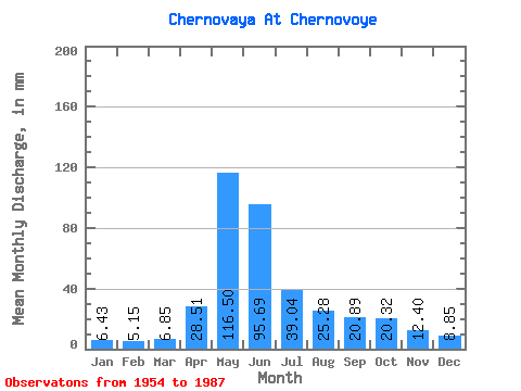
| Statistic | Jan | Feb | Mar | Apr | May | Jun | Jul | Aug | Sep | Oct | Nov | Dec | Annual |
|---|---|---|---|---|---|---|---|---|---|---|---|---|---|
| Mean | 6.43 | 5.19 | 6.86 | 28.51 | 116.48 | 95.69 | 39.03 | 25.27 | 20.89 | 20.32 | 12.40 | 8.84 | 384.63 |
| Standard Deviation | 1.26 | 1.11 | 1.37 | 10.72 | 31.16 | 57.73 | 22.85 | 12.96 | 11.12 | 10.48 | 3.70 | 1.93 | 110.50 |
| Min | 4.12 | 3.25 | 4.23 | 8.19 | 49.22 | 22.26 | 10.86 | 8.52 | 9.00 | 10.13 | 5.87 | 5.01 | 213.30 |
| Max | 10.19 | 7.46 | 10.91 | 53.89 | 178.72 | 241.42 | 114.69 | 69.59 | 66.82 | 61.80 | 22.20 | 13.70 | 633.50 |
| Coefficient of Variation | 0.20 | 0.21 | 0.20 | 0.38 | 0.27 | 0.60 | 0.58 | 0.51 | 0.53 | 0.52 | 0.30 | 0.22 | 0.29 |
 Return to R-Arctic Net Home Page