|
|
|||||||||||||||||
| Point ID: 6972 | Downloads | Plots | Site Data | Code: 11126 |
|
|
|||||||||||||||||
| Download | |
|---|---|
| Site Descriptor Information | Site Time Series Data |
| Link to all available data | |
| View: | Time Series | All |
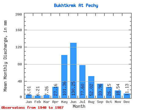
| Units: | m3/s |
| Statistic | Jan | Feb | Mar | Apr | May | Jun | Jul | Aug | Sep | Oct | Nov | Dec | Annual |
|---|---|---|---|---|---|---|---|---|---|---|---|---|---|
| Mean | 8.01 | 6.26 | 7.26 | 27.16 | 101.34 | 130.25 | 77.59 | 52.01 | 33.96 | 26.15 | 18.54 | 11.13 | 498.14 |
| Standard Deviation | 2.92 | 2.05 | 2.55 | 14.54 | 26.16 | 51.89 | 32.23 | 21.19 | 16.34 | 11.34 | 19.94 | 4.43 | 137.46 |
| Min | 3.83 | 2.98 | 3.79 | 9.41 | 35.52 | 44.59 | 33.77 | 28.22 | 11.71 | 12.14 | 6.92 | 4.37 | 259.01 |
| Max | 18.23 | 13.05 | 17.06 | 67.26 | 172.55 | 240.31 | 158.49 | 142.49 | 107.31 | 69.49 | 148.49 | 25.45 | 898.15 |
| Coefficient of Variation | 0.36 | 0.33 | 0.35 | 0.54 | 0.26 | 0.40 | 0.41 | 0.41 | 0.48 | 0.43 | 1.08 | 0.40 | 0.28 |
 Return to R-Arctic Net Home Page