|
|
|||||||||||||||||
| Point ID: 6971 | Downloads | Plots | Site Data | Code: 11124 |
|
|
|||||||||||||||||
| Download | |
|---|---|
| Site Descriptor Information | Site Time Series Data |
| Link to all available data | |
| View: | Time Series | All |
| Units: | m3/s |
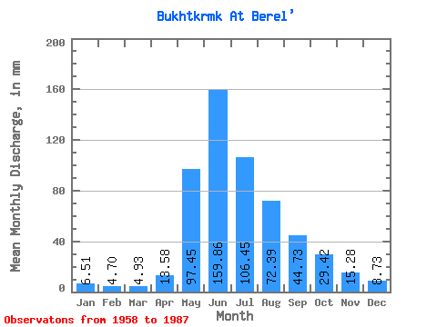
| Statistic | Jan | Feb | Mar | Apr | May | Jun | Jul | Aug | Sep | Oct | Nov | Dec | Annual |
|---|---|---|---|---|---|---|---|---|---|---|---|---|---|
| Mean | 6.51 | 4.74 | 4.93 | 13.58 | 97.44 | 159.86 | 106.44 | 72.38 | 44.73 | 29.42 | 15.28 | 8.73 | 561.97 |
| Standard Deviation | 1.35 | 1.23 | 1.40 | 5.08 | 25.63 | 58.62 | 33.59 | 20.95 | 13.15 | 8.44 | 4.07 | 2.10 | 107.89 |
| Min | 4.11 | 2.56 | 2.30 | 3.67 | 50.95 | 60.11 | 51.53 | 35.47 | 22.98 | 16.79 | 7.59 | 5.67 | 328.98 |
| Max | 9.08 | 7.10 | 9.44 | 26.06 | 140.12 | 320.85 | 175.16 | 131.87 | 77.48 | 53.99 | 27.74 | 15.49 | 738.77 |
| Coefficient of Variation | 0.21 | 0.26 | 0.28 | 0.37 | 0.26 | 0.37 | 0.32 | 0.29 | 0.29 | 0.29 | 0.27 | 0.24 | 0.19 |
 Return to R-Arctic Net Home Page