|
|
|||||||||||||||||
| Point ID: 697 | Downloads | Plots | Site Data | Code: 07CD005 |
|
|
|||||||||||||||||
| Download | |
|---|---|
| Site Descriptor Information | Site Time Series Data |
| Link to all available data | |
| View: | Time Series | All |
| Units: | m3/s |
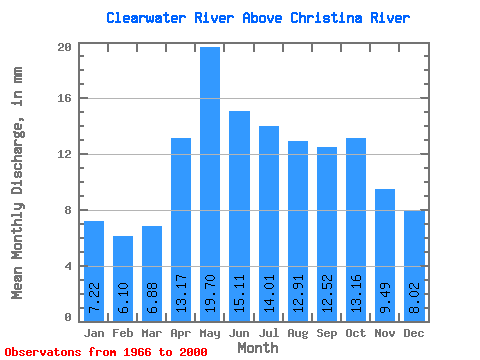
| Statistic | Jan | Feb | Mar | Apr | May | Jun | Jul | Aug | Sep | Oct | Nov | Dec | Annual |
|---|---|---|---|---|---|---|---|---|---|---|---|---|---|
| Mean | 7.22 | 6.15 | 6.88 | 13.17 | 19.70 | 15.11 | 14.01 | 12.91 | 12.52 | 13.15 | 9.49 | 8.02 | 136.03 |
| Standard Deviation | 1.30 | 1.11 | 1.16 | 3.43 | 5.25 | 3.31 | 4.51 | 4.45 | 4.31 | 4.62 | 1.81 | 1.48 | 21.08 |
| Min | 5.28 | 3.82 | 4.08 | 7.46 | 12.73 | 10.03 | 8.07 | 6.84 | 6.22 | 6.62 | 6.56 | 5.61 | 102.93 |
| Max | 9.59 | 8.12 | 9.17 | 21.04 | 34.34 | 23.33 | 26.78 | 23.31 | 23.48 | 23.79 | 14.01 | 10.88 | 181.75 |
| Coefficient of Variation | 0.18 | 0.18 | 0.17 | 0.26 | 0.27 | 0.22 | 0.32 | 0.34 | 0.34 | 0.35 | 0.19 | 0.18 | 0.15 |
 Return to R-Arctic Net Home Page