|
|
|||||||||||||||||
| Point ID: 6968 | Downloads | Plots | Site Data | Code: 11108 |
|
|
|||||||||||||||||
| Download | |
|---|---|
| Site Descriptor Information | Site Time Series Data |
| Link to all available data | |
| View: | Time Series | All |
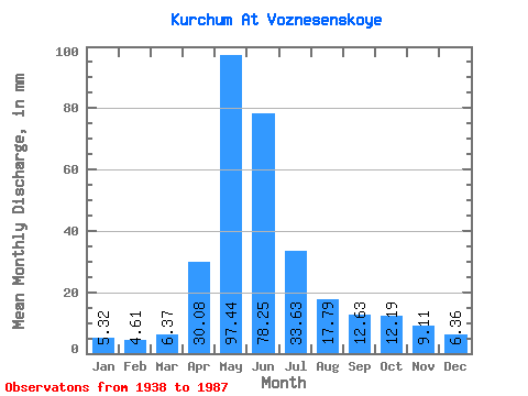
| Units: | m3/s |
| Statistic | Jan | Feb | Mar | Apr | May | Jun | Jul | Aug | Sep | Oct | Nov | Dec | Annual |
|---|---|---|---|---|---|---|---|---|---|---|---|---|---|
| Mean | 5.32 | 4.65 | 6.37 | 30.08 | 97.42 | 78.25 | 33.62 | 17.79 | 12.63 | 12.19 | 9.11 | 6.36 | 311.18 |
| Standard Deviation | 1.38 | 1.37 | 2.18 | 11.09 | 31.68 | 39.43 | 17.19 | 8.42 | 4.96 | 4.74 | 3.17 | 2.03 | 94.98 |
| Min | 2.46 | 2.18 | 3.28 | 10.96 | 49.52 | 8.65 | 7.57 | 5.78 | 5.33 | 6.56 | 4.93 | 2.22 | 142.73 |
| Max | 9.49 | 9.73 | 12.34 | 58.14 | 169.21 | 192.18 | 92.17 | 42.69 | 25.88 | 26.14 | 20.95 | 10.27 | 555.65 |
| Coefficient of Variation | 0.26 | 0.29 | 0.34 | 0.37 | 0.33 | 0.50 | 0.51 | 0.47 | 0.39 | 0.39 | 0.35 | 0.32 | 0.30 |
 Return to R-Arctic Net Home Page