|
|
|||||||||||||||||
| Point ID: 6965 | Downloads | Plots | Site Data | Code: 11093 |
|
|
|||||||||||||||||
| Download | |
|---|---|
| Site Descriptor Information | Site Time Series Data |
| Link to all available data | |
| View: | Time Series | All |
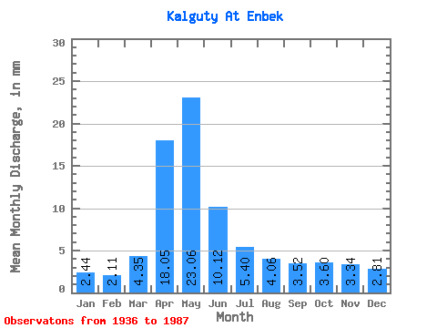
| Units: | m3/s |
| Statistic | Jan | Feb | Mar | Apr | May | Jun | Jul | Aug | Sep | Oct | Nov | Dec | Annual |
|---|---|---|---|---|---|---|---|---|---|---|---|---|---|
| Mean | 2.44 | 2.13 | 4.34 | 18.05 | 23.06 | 10.12 | 5.40 | 4.06 | 3.52 | 3.60 | 3.34 | 2.81 | 108.91 |
| Standard Deviation | 1.06 | 1.33 | 3.85 | 13.91 | 18.81 | 7.91 | 3.45 | 2.80 | 1.98 | 1.54 | 1.61 | 1.56 | 89.27 |
| Min | 1.15 | 0.33 | 0.38 | 3.81 | 3.06 | 1.22 | 0.47 | 0.06 | 0.58 | 0.87 | 0.79 | 0.55 | 23.56 |
| Max | 4.37 | 4.53 | 11.15 | 72.47 | 93.46 | 42.90 | 14.43 | 12.90 | 11.64 | 6.89 | 7.62 | 5.52 | 257.62 |
| Coefficient of Variation | 0.43 | 0.62 | 0.89 | 0.77 | 0.82 | 0.78 | 0.64 | 0.69 | 0.56 | 0.43 | 0.48 | 0.56 | 0.82 |
 Return to R-Arctic Net Home Page