|
|
|||||||||||||||||
| Point ID: 6964 | Downloads | Plots | Site Data | Code: 11090 |
|
|
|||||||||||||||||
| Download | |
|---|---|
| Site Descriptor Information | Site Time Series Data |
| Link to all available data | |
| View: | Time Series | All |
| Units: | m3/s |
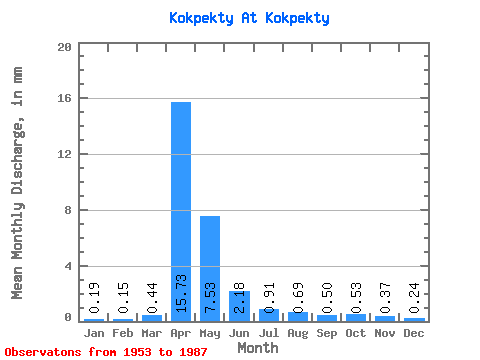
| Statistic | Jan | Feb | Mar | Apr | May | Jun | Jul | Aug | Sep | Oct | Nov | Dec | Annual |
|---|---|---|---|---|---|---|---|---|---|---|---|---|---|
| Mean | 0.19 | 0.15 | 0.44 | 15.73 | 7.53 | 2.18 | 0.91 | 0.69 | 0.50 | 0.53 | 0.37 | 0.24 | 32.00 |
| Standard Deviation | 0.12 | 0.11 | 0.82 | 13.86 | 7.86 | 1.83 | 0.92 | 1.03 | 0.66 | 0.52 | 0.23 | 0.15 | 23.63 |
| Min | 0.03 | 0.02 | 0.03 | 1.17 | 0.99 | 0.40 | 0.12 | 0.11 | 0.15 | 0.16 | 0.08 | 0.01 | 7.67 |
| Max | 0.55 | 0.51 | 3.34 | 47.24 | 38.13 | 8.84 | 3.86 | 4.79 | 3.61 | 2.78 | 0.90 | 0.62 | 98.97 |
| Coefficient of Variation | 0.62 | 0.69 | 1.84 | 0.88 | 1.04 | 0.84 | 1.00 | 1.50 | 1.32 | 0.98 | 0.63 | 0.62 | 0.74 |
 Return to R-Arctic Net Home Page