|
|
|||||||||||||||||
| Point ID: 6940 | Downloads | Plots | Site Data | Code: 10652 |
|
|
|||||||||||||||||
| Download | |
|---|---|
| Site Descriptor Information | Site Time Series Data |
| Link to all available data | |
| View: | Time Series | All |
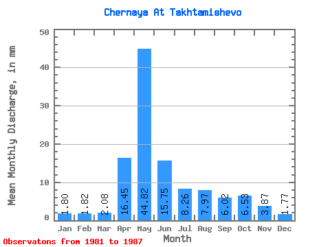
| Units: | m3/s |
| Statistic | Jan | Feb | Mar | Apr | May | Jun | Jul | Aug | Sep | Oct | Nov | Dec | Annual |
|---|---|---|---|---|---|---|---|---|---|---|---|---|---|
| Mean | 1.81 | 1.84 | 2.08 | 16.45 | 44.82 | 15.75 | 8.26 | 7.97 | 6.02 | 6.53 | 3.87 | 1.77 | 118.23 |
| Standard Deviation | 0.66 | 0.85 | 0.92 | 8.63 | 23.27 | 7.35 | 4.99 | 7.91 | 3.31 | 2.68 | 2.23 | 0.61 | 59.03 |
| Min | 0.89 | 0.55 | 0.64 | 5.08 | 14.01 | 7.68 | 2.68 | 1.96 | 1.79 | 3.30 | 1.59 | 1.24 | 62.01 |
| Max | 2.47 | 2.63 | 3.09 | 28.31 | 77.25 | 28.11 | 15.04 | 21.42 | 9.77 | 9.68 | 7.28 | 2.78 | 196.14 |
| Coefficient of Variation | 0.37 | 0.47 | 0.44 | 0.53 | 0.52 | 0.47 | 0.60 | 0.99 | 0.55 | 0.41 | 0.58 | 0.34 | 0.50 |
 Return to R-Arctic Net Home Page