|
|
|||||||||||||||||
| Point ID: 6938 | Downloads | Plots | Site Data | Code: 10626 |
|
|
|||||||||||||||||
| Download | |
|---|---|
| Site Descriptor Information | Site Time Series Data |
| Link to all available data | |
| View: | Time Series | All |
| Units: | m3/s |
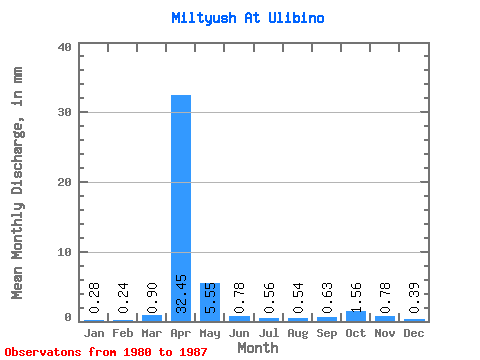
| Statistic | Jan | Feb | Mar | Apr | May | Jun | Jul | Aug | Sep | Oct | Nov | Dec | Annual |
|---|---|---|---|---|---|---|---|---|---|---|---|---|---|
| Mean | 0.28 | 0.24 | 0.90 | 32.45 | 5.55 | 0.78 | 0.56 | 0.54 | 0.62 | 1.56 | 0.78 | 0.39 | 45.45 |
| Standard Deviation | 0.11 | 0.14 | 1.14 | 10.91 | 3.84 | 0.63 | 0.43 | 0.24 | 0.72 | 0.84 | 0.45 | 0.27 | 15.09 |
| Min | 0.13 | 0.06 | 0.11 | 18.56 | 0.62 | 0.14 | 0.20 | 0.17 | 0.19 | 0.73 | 0.26 | 0.09 | 24.82 |
| Max | 0.43 | 0.47 | 3.44 | 48.91 | 11.41 | 1.66 | 1.30 | 0.89 | 2.37 | 3.33 | 1.56 | 0.89 | 63.77 |
| Coefficient of Variation | 0.40 | 0.57 | 1.27 | 0.34 | 0.69 | 0.81 | 0.76 | 0.44 | 1.16 | 0.54 | 0.57 | 0.68 | 0.33 |
 Return to R-Arctic Net Home Page