|
|
|||||||||||||||||
| Point ID: 6934 | Downloads | Plots | Site Data | Code: 10622 |
|
|
|||||||||||||||||
| Download | |
|---|---|
| Site Descriptor Information | Site Time Series Data |
| Link to all available data | |
| View: | Time Series | All |
| Units: | m3/s |
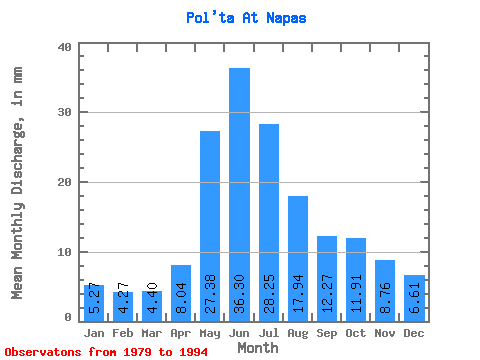
| Statistic | Jan | Feb | Mar | Apr | May | Jun | Jul | Aug | Sep | Oct | Nov | Dec | Annual |
|---|---|---|---|---|---|---|---|---|---|---|---|---|---|
| Mean | 5.27 | 4.30 | 4.40 | 8.04 | 27.37 | 36.30 | 28.25 | 17.93 | 12.27 | 11.91 | 8.76 | 6.61 | 170.69 |
| Standard Deviation | 1.22 | 0.83 | 0.59 | 4.21 | 13.59 | 9.39 | 13.61 | 11.77 | 5.86 | 2.91 | 2.72 | 2.31 | 41.80 |
| Min | 3.39 | 2.98 | 3.48 | 4.25 | 8.50 | 22.34 | 9.69 | 6.35 | 6.89 | 7.91 | 4.77 | 3.85 | 104.65 |
| Max | 7.82 | 5.98 | 5.30 | 17.51 | 48.15 | 54.87 | 59.83 | 46.30 | 29.50 | 16.52 | 13.79 | 10.91 | 269.46 |
| Coefficient of Variation | 0.23 | 0.19 | 0.13 | 0.52 | 0.50 | 0.26 | 0.48 | 0.66 | 0.48 | 0.24 | 0.31 | 0.35 | 0.24 |
 Return to R-Arctic Net Home Page